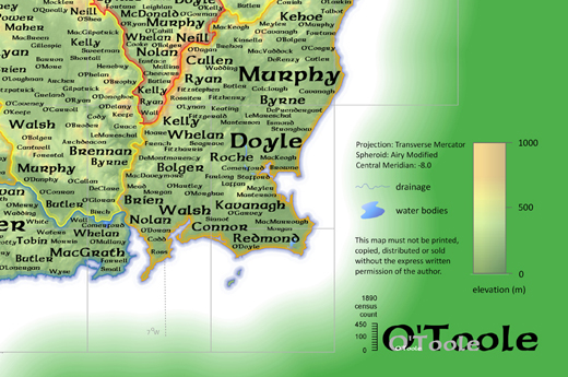
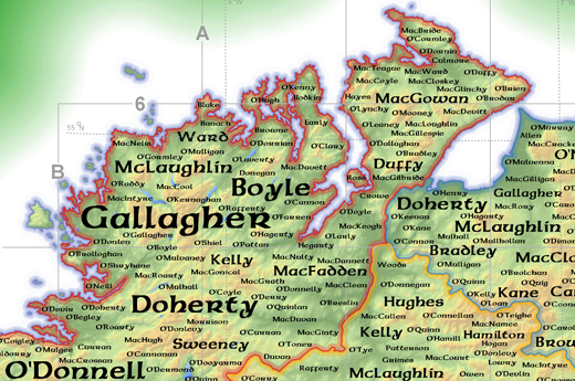
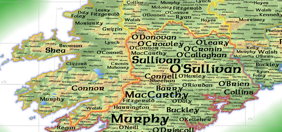
Have you ever wondered where your Irish family name is most common or originates from in Ireland? If you’re like most Irish Americans in the weeks following St. Patrick’s Day, the answer is almost certainly yes. And to get the answers, cartographer Kenneth Field and the American Geographical Society have shared an interactive map of Ireland based on the 1890 census that stunningly and intuitively illustrates the density and origin of over 1,000 Irish surnames.
The map, called “Mapping the Emerald Isle: A Geo-Genealogy of Irish Surnames” and originally created in 2009, provides “a visual representation of the spatial and quantitative distribution of birth data from the 1890 Irish census of population,” according to its developers, Field and Dr. Linda Beale. Their research led them to seek to categorize and visualize the surnames of every child born by county with a quick and easy sized scale to indicate how many babies born that year shared a given surname.

An additional feature of this map is that as well representing the births of the 1890 census, the names and the quantity of those names reflect the historic importance those families meant to the people that surrounded the land, giving insight into the history of clan conquests and movements.
Once you click through to the link, you’ll find the map of Ireland, and a search bar in the top left corner of your internet browser. In this search bar, you can search pretty much any Irish name you can think of and it will come up with a result of where the name appeared in any county at the time of the 1890 census.

An example would be the name Boyle, I typed the name into the search bar and it found that the name Boyle appeared in four counties, Donegal, Louth, Roscommon, and Sligo. In addition to the general county the name appears in, the map also provides how many households the name belongs to. In Donegal, the Boyle name appears in 102 households more specifically in the region of Ramelton and Milford and Kilmacrenan. However, if you search the name O’Boyle, you’ll only find one county, Donegal, and one household that holds that name.
Not only are you allowed to search names in the map, you can physically click the map itself enabling the user to find not only the most common names but names that are not so common, the user can find this by the size of the font in relation to the name.

The map is wonderfully designed as it not only has good use of colors, but has design elements of Ireland’s past such as Celtic knots and a font that is similar to the Irish type script. “A Celtic theme and connotations with the ‘Emerald Isle’ added to the impact of the map as a product that would inspire people to view, interact with, and study; to evoke feelings of longing, recollection, and familiarity,” Field writes of his original design process. “This is what we call the ‘affective design’ of the map…. the result of a design process that marries aesthetics with usability. These would serve to give the map a strong identity and one which people would ‘warm to.’”
Made with free cloud based ArcGIS software, the map has won several awards for its usability and design, including the 2010 John C. Bartholomew award for small scale mapping and the 2009 People’s Choice map gallery award at the Esri International User Conference.
Whether you know where your family is from or not, this map of Ireland could provide the inkling that leads you on a journey of Irish ancestral self-discovery. View the map by clicking here, and enjoy. ♦
_______________
Did you find your surname on the map? Did you learn anything surprising about your ancestors or relatives? Let us know in the comments! Dave Lewis


There wasn’t an 1890 Census of ireland it was in 1891. But the data used for the maps is actually based on civil registration data rather than
census data!
This is a link to a description of the actual source and it’s not from census data: https://www.ancestryireland.com/family-records/distribution-of-surnames-in-ireland-1890-mathesons-special-report/
Couldn’t find the name Mitchell in Galway. Does anyone know about it.
Trying to see the whole map, especially for west cork complete area, how,I view it. I am on iPad no adobe.
Didn’t find DOWLING…but did find an O’DOWLING..are they one in the same???
Murphy is shown in southwest Kerry. It is the most plentiful surname in Ireland, also in 3 Irish counties, including Armagh, which is one of the Six Counties north of the artificial Partition.
My surname “Keenan” doesn’t come up in the search results and seldom does yet birth and marriage certificates for my grandparents and great grand parents are registered under that name. I’ve been hoping to find the trail back to the gr gr grandparents.
There are Mitchells nextdoor in Co Mayo
Love the surname maps in this size 5230×345 but miss the maos top right, middle left and bottom left so that I can have a complete map that I can read finally jippi other maps are hard to read